

Ever since the Phoenicians, people used boats to populate the region around the Mediterranean Sea. Civilizations sprung up around rivers, and rivers were used to explore and settle the hinterland. They were economical and military arteries, used for trading, raiding and conquering in those times when roads were hard to construct, maintain and keep safe.
The Romans pushed north into Gallia (France and Belgium), then crossed the Channel to England. On the continent the Rhine river was fortified to serve as a demarcation line between the Roman Empire and Germania after the conquest of Gallia by Julius Caesar. Centuries later the Vikings attacked from the North, subduing England and rowing their drakkars as far inland as Paris before settling for Normandy, named after them, the Normans, literally "men from the North". The same Normandy that William the Conqueror would use as a base to capture the English throne.
But they didn't content themselves with Western Europe alone. Far in the East a man named Rurik and his brothers and kinsmen worked their way down the rivers that flow down to the Black and Caspian Seas. He and his successors explored the Dniepr, the Don, the Volga and all their tributaries. Massive rivers stretching North to South, but with cataracts that can only be crossed by lifting the boat out of the water and carrying it to the bottom, highlighting a much underestimated quality of the lightly built drakkars.
After Rurik made Novgorod his capital (being Scandinavians, they called it Holmgård), his descendants moved it to Kiev. And so his kingdom would be called Kievan Rus, Rus being a contraction of his own name. There are Russians and Ukrainians alike that claim descent from these rough hewed, axe wielding adventurers. (Linguists however disagree, as there are very few traces of Old Norse in the Slavic languages spoken today, unlike the influence that Norman French had on the English language. It's more likely that the invaders were absorbed in the greater Slavic population, without leaving much of a cultural mark.)
Soon drakkars sailed the Black Sea, appearing in front of the Golden Horn, the entrance to Constantinople and the Mediterranean. From the other end Vikings fought their way through the Strait of Gibraltar into the Mediterranean, settling themselves in Sicily and other places. It wouldn't be too much of a distortion to say that the Vikings were the first to circumnavigate Europe.
That travel is faster by ship than by land in a time when oxen carts determined the pace of the voyage on foot, is amply demonstrated by the spread of the Black Plague (also called the Bubonic Plague). The first pandemic is said to have been carried by rodents on board Genoese galleons fleeing a lost battle in the Crim, where the Turks had catapulted infected dead bodies of their own men into the city the Genoese were defending. They came through Constantinople, starting a pandemic there, then on to Pisa where half the population got killed in a pattern that would repeat itself all over Europe. The rats got on board ships bound for France, Spain and England, laying waste to every harbour visited with cruel efficiency. In a matter of months they reached Norway before even crossing the Alps to Bavaria. Novgorod was hit in good time from ships sailing on the Baltic Sea, but the circle was not completed as the Russian hinterland was never truly exposed. The fact that rivers were not connected yet by canals might have been a factor in preventing the further spreading.
Fast forward to the first half of the 20th century. In the turmoil of World War I Communism had triumphed, the Czar deposed and murdered along with his offspring, the Whites defeated and Russia had become the Soviet Union. Stalin had emerged as the fearsome leader, sending millions of people to the Gulag. They were cheap labor, as coercion and the promise of a a sentence reduction and physical activity was sufficient to make many of them work (and oftentimes die) on the gigantic state projects that the Soviets undertook.
In this giant country there were many of these undertakings, but the canal projects were certainly among the most ambitious. The construction or improvement of canals that would connect the Black Sea to the Caspian Sea and these in turn by way of the Volga to the Baltic and the Arctic Sea, were of the highest priority. Stalin wanted his fleets to be able to move from one sea to another without needing to move through international waters. As a result the depth and width of these canals, rivers, lakes and all of the locks were dimensioned after the biggest warships of the day.
The first part was to connect the Don, which flows into the Black Sea, to the Volga, which feeds the Caspian Sea. For this a canal was dug starting close to Stalingrad (present-day Volgograd), where the distance between the two rivers is the shortest. Next an existing system of canals and locks, built in the 18th century and connecting the Volga with the Baltic Sea, was expanded to accommodate for the passage of warships. Finally a canal was built in the cold Arctic North connecting Lake Ladoga, which was already part of the Baltic-Volga waterway, to the White Sea. When the author and playwright Gorky visited the work in progress, he lauded the toils of the laborers. But the reality was probably much more grim and the death toll, as most of it was hand labor in appalling conditions, was reportedly high. The hubris.
Did these newly built canals play a role during WWII? It did at the start to bring newly built ships from the new shipyards in Gorky (named after the writer) to the Baltic. But after Germany invaded and quickly marched up and encircled St. Petersburg, that passage got blocked. And Stalin had better things to do than to position a navy in the Arctic waters. Like using them as a natural border, whether during a battle or a siege. One prominent example is the Battle of Stalingrad, in which the Germans drove the Russian army over the river Volga, where they regrouped on the eastern bank across the city located on the western bank. While the Germans tried to clear the city house by house in what is now called urban warfare, the Russian army supported the citizens inside through risky nightly crossings and later constant bombardments as the Germans gained more and more ground. With only a few pockets of resistance left in areas close to the river, the Russians started a counteroffensive, cutting through the overextended Rumanian and Italian auxiliary groups guarding the western bank outside the city, then joining up and enveloping the city. A second phase of urban warfare started, now with the trapped Germans as the defenders, until their surrender one and a half month later, starving, out of munition and without hope for relief.
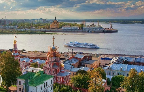
After the war the Volga canal system became more important for commerce, although Gorky, a city located in the middle of the continent on the banks of the Volga, continued to produce anything from submarines to pleasure cruises. To this day Nizhny Novgorod, as it's now called, is the biggest shipbuilding hub in Russia.
What does this all have to do with the Modern map? When we look at the map, it's a surprise to see that Vincent Mous didn't take advantage of this existing network. The only part included is the connection between the Caspian Sea and the Black Sea, and even there he once confided to me that he wasn't too happy about including it. There are no canals or rivers in Standard, except for the one space Kiel canal. But Modern is a much more detailed map in a different time period. There are powers like Ukraine and Poland that have to work hard to break out of their pond, let alone cross over to the seas at the opposite side of the map. They are effectively constrained to being land powers for most of the game, notwithstanding the fact that Ukraine has two solid ports. Without control of the seas, breaking through stalemate lines becomes that much harder and the number of attainable centers much more limited.
No doubt Vincent will counter that the Modern map was designed to be played with Wings in addition to Fleets and Armies. Wings are not limited by coastal features and can move to any neighbouring territory anywhere on the map, whether it's land or water. They cannot however capture cities or convoy armies and thus have mostly a supporting role. With Wings Ukraine and Poland should have less problem advancing across the board, into Scandinavia and Africa, even if they would still have difficulty attacking the British islands.
True, but the fact is that most Modern games are played without Wings. This is mostly by necessity, as few Judges have implemented support for them. The DPjudge for example lacks this capability. And still people choose to play the Modern map, as it's without doubt one of the most popular variant map around. Making it non-Wings friendly should be considered a plus. To that end I added a canal system that allows to circumnavigate Europe. Or rather, I implemented what already exists in the modern world.
Why stop at the Russian canals? Why not add all the other great waterways in Europe? Because few of them are also interconnected in a way that would allow passage from one sea to another. With only a few exceptions, canals tend to connect rivers that flow into the same sea.
The first of these exceptions is the well-known Kiel canal, connecting the North Sea to the Baltic Sea, serving a similar purpose as the natural Oresund connection through Denmark. Then there's the Canal du Midi in the south of France, roughly parallel to the Pyrenees that straddle the border with Spain. Built during the reign of Louis XIV, le Roi Soleil, this canal connects the Mediterranean to rivers flowing through Bordeaux towards the Atlantic Ocean. Unfortunately it never fulfilled its destiny of becoming one of the great waterways in Europe, simply because of its dimensions. With a depth of only 2 meters and bridges too low for sailing boats to pass under, it was mostly used by barges to transport the wine and wheat of the region to the Mediterranean ports. Nowadays it's mostly a tourist attraction, having lost even its commercial appeal to rail and road.
The last great exception that I want to mention is the Rhine-Danube canal (or in full the Rhine-Main-Danube canal), connecting the two most prominent rivers in Europe outside the states of the old Soviet Union. This canal was completed in 1992, only 3 years before the traditional starting year of a Modern game. Even if the canal itself is located completely inside Germany, the whole system runs through many countries that are all part of or associated with the EU. Its stated goals are therefore purely commercial, not military.
It links the North Sea to the Black Sea, with no offshoots to other seas, like the Baltic or the Adriatic. In game terms this would provide a single path for fleets to follow through the center of the continent that would take them through about eight land provinces. The chance of actually reaching the other side before the game ends is so small that not many will ever attempt it. Compare this to the four spaces that the Volga route occupies between the Black Sea and the Baltic Sea, with its offshoots to the Caspian and White Sea. This Volga route is also located in a corner of a map, making control of the region by a single power much more feasible. In short, the Volga route is much more likely to be used productively than the Rhine-Danube route. And that is still a determining factor in any proposed map change.
Did you know that Moscow is called the "city of the five seas"? That's because the Russian capital is connected to the Volga through the Moscow Canal. But wait, five? There's the Black Sea, the Caspian Sea, the Baltic Sea, the White Sea and ... the Sea of Azov. Never heard of the last one? Quite possible. It's in the north-eastern corner of the Black Sea, to the right of the Crim peninsula, connected to the rest of the Black Sea by the Strait of Kerch. Its eastern extremity is where the Don empties into the Black Sea, close to the Ukrainian-Russian border, near the city of Rostov or, to be fully correct, Rostov-on-the-Don. This gives us an excellent excuse to make two more changes.
The first is to redraw the first part of the Don-Volga river system on the border of the provinces of Donbas in the Ukraine and Rostov in Russia. This simple change allows a fleet to move between Donbas and the Volga province without moving through Rostov, a home center. Since centers are usually more actively defended than provinces without centers, there's a slightly higher chance that this kind of move might work, even without support. The fact that the real-life border is more to the North (indeed, the Don runs in Russia for its entire length) is less of a concern. In times of war, the frontline would quickly move up to the river, a natural border, rather than any political border decided in times of peace.
The second change is to make the Sea of Azov its own space, separate from the Eastern Black Sea, to which it would still be connected. Oddly enough the original Modern map had been drawn such that it looked like the Sea of Azov connected also to the Western Black Sea, because the Crim peninsula was shown as an island, disconnected from the Ukrainian mainland. In reality there's a solid land connection called the Perekop Isthmus , about 5 km wide at its narrowest point. To its east is the Syvash, an extensive area of very shallow and thus unnavigable lagoons, 35 km in width and separated from the Sea of Azov proper by the Arabat Spit, a long and narrow sand bank interrupted only at its most northern and southern extremities. Most small scale maps will consider it part of the land mass, showing the Crimea solidly connected to the continent. I followed this convention in redrawing the coastline, thereby making the Crim a true peninsula.
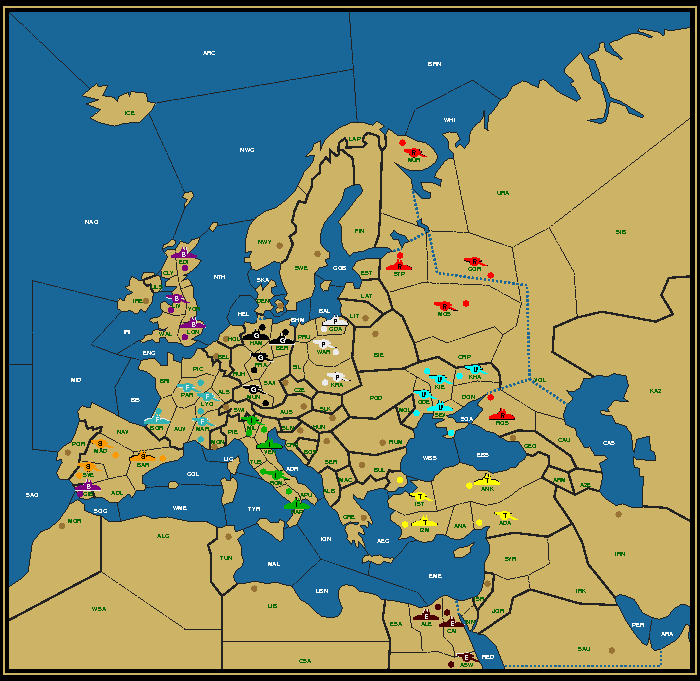
Given that the Sea of Azov only has one adjacent sea, it functions much like the Adriatic Sea in Standard or indeed on the Modern map. It facilitates attacks on the adjacent home centers (Sevastopol and Rostov), making it easier to conquer them from the sea, and provides a convoy route to and from Donbas. Previously Donbas sat adjacent the Eastern Black Sea, allowing a sneaky convoy from or to Ankara or Georgia using just a single fleet. This convoy is still possible, but will now require two fleets and therefore might be more obvious. I prefer clarity over obscurity when it comes to coastlines, so I consider this a plus. Note that although the Sea of Azov is where the river Don flows into, it's still possible to move from the Eastern Black Sea through Rostov to Volga without passing through this new space, because rivers and canals are considered an integral part of the coastline for movement purposes.
How do these changes affect game play? To find out I've been organizing trial games on USDP and UKDP. Three of them have finished so far, all of them on a map version lacking the Sea of Azov space. All of these games are team games, whereby a player is assigned two powers each and victory is obtained if the combined total exceeds half of the total number of supply centers. Most are no-press. This helps to keep the games fast and short, but exceptions are possible.
In games teamtag on UKDP and lovestruck on USDP the canals didn't play much of a role. In lovestruck the Russo-Ukrainian team steamrolled the rest of the board without ever looking back. Teamtag saw (or perhaps "felt", as this was a blind game) Poland-Turkey first roll up the Ukraine before turning on Russia, but got outpaced and enveloped by Germany-Egypt which managed to make the Balkans its own. Russia was brought to the brink of elimination, but no fleet other than a lone Ukrainian ever entered the Russian hinterland. In both games the fact that the dominant player had powers both in the Black Sea and the North with ports that were never threatened obviated the need to use the canals.
The third game was more interesting. This was game lovespiel, again on USDP. Early on Britain ventured with a fleet up North into Murmansk and moved through the White Sea Canal to St. Petersburg. But lacking follow-up the fleet was quickly pushed back the way she came and Russia's North was never again threatened. Much later in this very long game, which lasted for more than 25 game years (setting a new record for team games), after Turkey had evicted Russia from Rostov, Russia built a fleet in Gorky (which was a first) and sent it to the Caspian Sea. This forced Turkey to stab his Italian ally in order to build enough units to prevent a Russian breakthrough in the Middle-East. This game ended in a rare three-way (at least for no-press team games), shared between Russia (with Spain), France (with Poland) and Turkey.
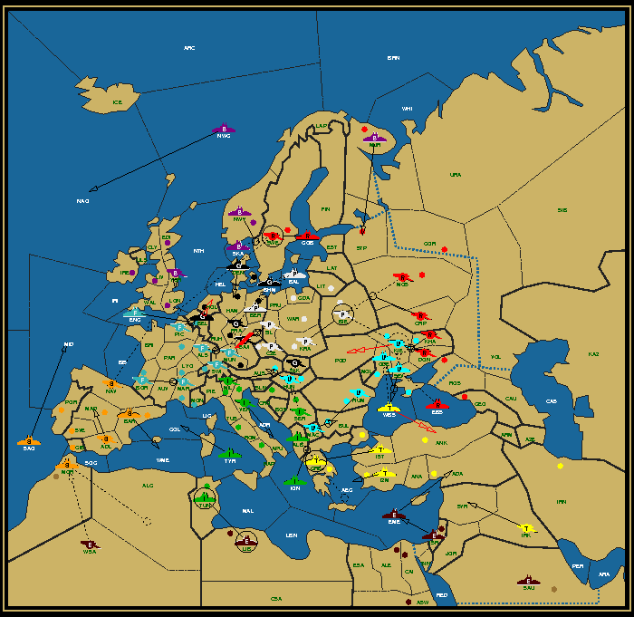
My impression so far is that the canals benefit Russia more than its neighbors. Of course, three games are but a poor sample, but the fact that Russia no longer needs to fear the loss of a single port makes its 5 home centers a comparatively greater competitive advantage than before. But this is just an impression. Other cases can be made. It will be interesting to see what the future holds in store. A circumnavigation of Europe perhaps? Who knows where the traveler might go.

|
Mario Huys (woelpad@gmail.com) |
If you wish to e-mail feedback on this article to the author, and clicking
on the envelope above does not work for you, feel free to use the
Dear DP...
mail interface.